


Garmin Foretrex 401
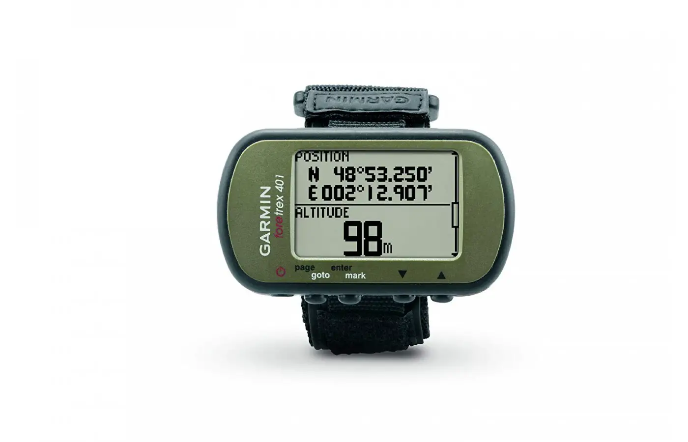

The newly updated, industrial design is lighter and smaller than previous models for increased mobility and comfort. Five ergonomically situated buttons intuitively guide the user through the functions. It is an easy single-handed operational system. The highly sensitive receiver offers reception in urban jungles, dense tree cover and narrow valleys with quick acquisition and lock. Additional navigational aids include a barometric altimeter and electronic compass.
Routes, tracks, and waypoints can be effortlessly shared with other Garmin units that have an ANT wireless communications function. The device is compatible with the GSC 10 Speed and Cadence Sensor and Garmin heart rate monitors. Whether hitting the slopes, biking, or hiking, the user always knows the location. The device securely mounts on the wrist and requires no removal of the hands from bicycle handlebars or trekking poles.
- Accurate
- Awesome signal reception
- Easy to use
- Inexpensive
- Lightweight
- Small
- Rugged
- Wrist strap
- Altimeter issues
- Lacks software support
- Maps cannot be saved on the unit
Basic Features
The Garmin Foretrex 401 is highly recommended for those who want something easy to use, reliable, and small. The outstanding, small Garmin Foretrex 401 is a wrist-mounted GPS. Basic information while walking or running is quite informative.
Pace time is not provided, but all the information on the compact Garmin is at the user’s fingertips. The Foretrex 401 is geared for the military. It is approximately 20 percent smaller than its predecessor. The device has the same backlit display.
We have also reviewed a newer model, the Foretrex 601, so make sure you check that one out also.
It does not store maps, but that was not why this model was made. It lacks some programs and added features found in other GPS. Many are features people do not use frequently. The lack of extra features is appealing to some because it is easier to use. Those wanting more than essential functions may wish to purchase something else.
Advanced Features
The high-sensitivity GPS chip of the Garmin Foretrex 401 rivals more expensive GPS units. The device sports a barometric altimeter and two-axis digital compass. Static HALO and HAHO jumping allow setting data points for guidance under a canopy to LZ thanks to the ‘Jumpmaster’ function.
It has options for HARP, wind speed at altitude, and forward throw to get the user to the right place. The unit can leave a bread-crumb trail when used to record and backtrack steps. It is an interesting function.
The Garmin Connect site is a site to log workouts. Data can be downloaded from the GPS to track workouts. The unit takes a couple of seconds before picking up a signal. The data screen has to be reset when the signal appears.
Data before the reset has to be deleted when downloading data to the Garmin Connect site. The problem may be with the Garmin Connect site and not the GPS. Turn on the TracBack feature to retrace a pather where it started.
Keep track of altitude and bearings with the barometric altimeter and electronic compass. Locations can be saved as waypoints in memory. The way back to important places such as a vehicle or campsite can always be found.
Use
Using USB routes and waypoints can be directly loaded to the device due to the compatible computer design. It is perfect for outdoor adventures and activities. Even when sweating, the unit is extremely comfortable. It can be worn for extended periods. In difficult terrain, it provides added confidence. The device can clone wirelessly with another 401. Routes and waypoints can be shared quickly with team members.
The sensitivity of GPS has been improved. It will pick up signals faster when out of an aircraft. It is best as a backup to a primary altimeter. In direct sun, the black and white, 1.8-inch screen is surprisingly readable. It is an excellent option for any location such as desert environments where bright sunlight is encountered.
Biking enthusiasts appreciate the cadence sensor and heartcompatibility. th are wireless. Data transfer is also a wireless transmission. The wrist attachment gives hands-free access to the GPS whenever needed.
The Garmin Foretrex 401 is a GPS with excellent features great for hiking. The design is simple but ingenious. It is lightweight and compact. The GPS is perfect for activities in which hands need to be such as military, skiing, and cycling.
The lightweight device is ideal for hikers, campers and skiers. It is worn on the wrist like a watch. Other helpful information includes fishing and hunting information and sunset/sunrise times.
Connectivity
The GPX format is used to store all routes. They can later be uploaded from the navigator to a computer through a USB cable. A detailed analysis of activities is made. A simple connection to a computer with internet access allows activities to be stored and analyzed after exploration.
Using Garmin Connect, tracks can be sent to the outdoor device. The one-step site offers a table of activities that can be viewed on a Google Earth map. Routes uploaded by millions of customers can be explored. Experiences can be shared on Facebook and Twitter.
Power Source
Many systems have rechargeable internal batteries. They provide more battery life but can’t be swapped if they die. With Foretrex, toss two more triple-As in, and the GPS is back and running.
Carrying extra triple-A batteries is not burdensome. Tracks, routes, and waypoints can be shared wirelessly with other Foretrex 401 GPS. A simple connection to a computer with internet access allows activities.
Accuracy
Durability
It arrives in a durable package. It weighs only 3.1 ounces when loaded with two triple-A batteries. The super lightweight Foretrex 401 fits nicely on a wrist. Durability is a strong point of the device. Units were banged around Afghanistan inside a vehicle and on dismounted patrol that were blown up two times and kept working.
Ease of Use
Possible settings include sunset, local time, grid reference, latitude, longitude, and MGRS. Due to the small size, it can be mounted on the wrist. There are substantial bolts fitted to the base that allow a watch band fitting.
The watch face can be face down on the wrist bottom with the Foretrex on top of the wrist. It can be strapped to a shotgun for immediate navigational data. Four buttons control the Garmin Foretrex in addition to the on/off button that also activates the backlight.
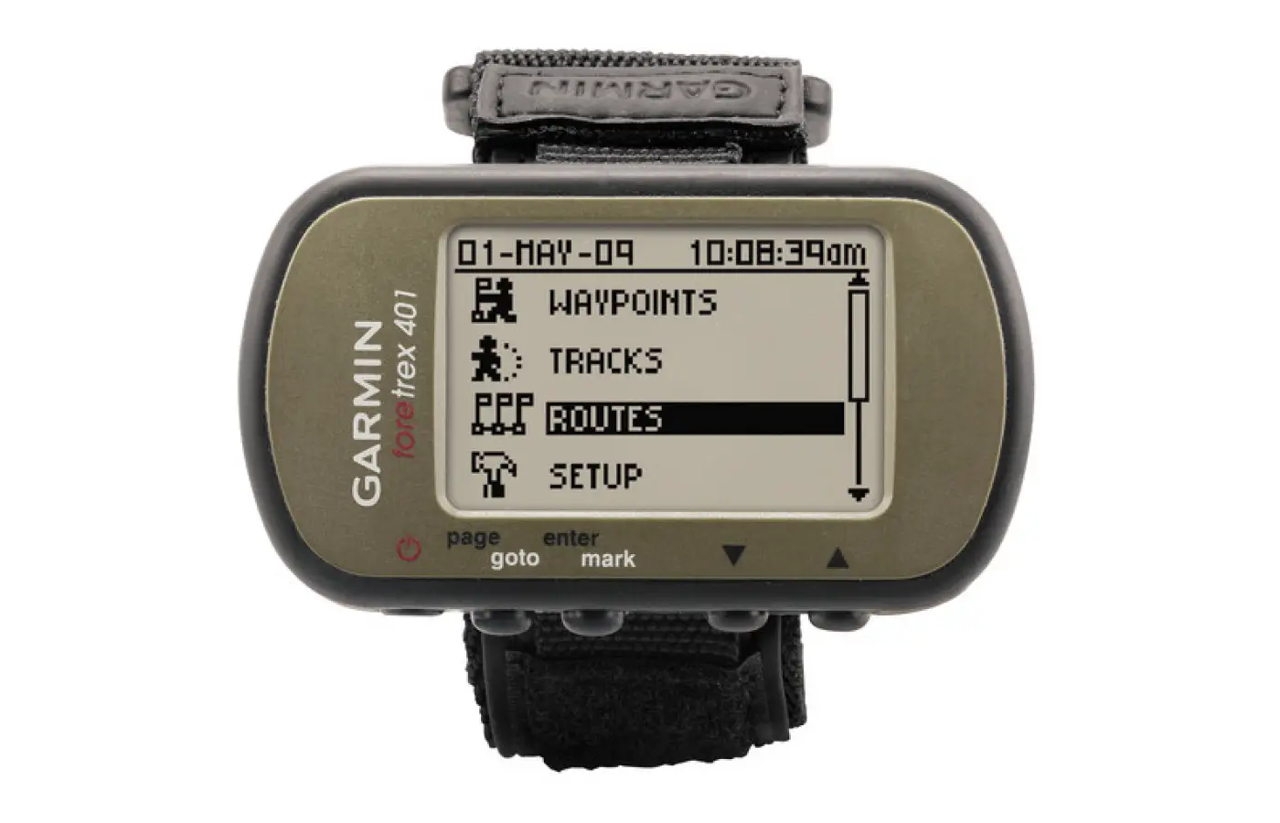
The large buttons respond well to pressing. A Page (Goto) button switches to an Options page, General page, Altimeter page, and Interactive map. The device settings also allow for a timer to be turned on and off. The Enter button is self-explanatory. Except for the input function, the button allows necessary points to be quickly marked. The two other buttons perform the up and down functions.
The Interactive map displays directions to the traversed path and the next point, as well as the map scale, a compass, and information about a current relative position. The Compass page contains approximate distance to the destination, current speed, and compass information.
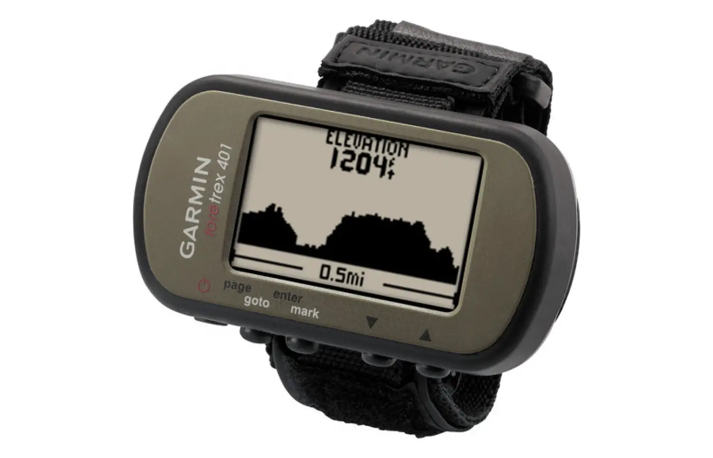
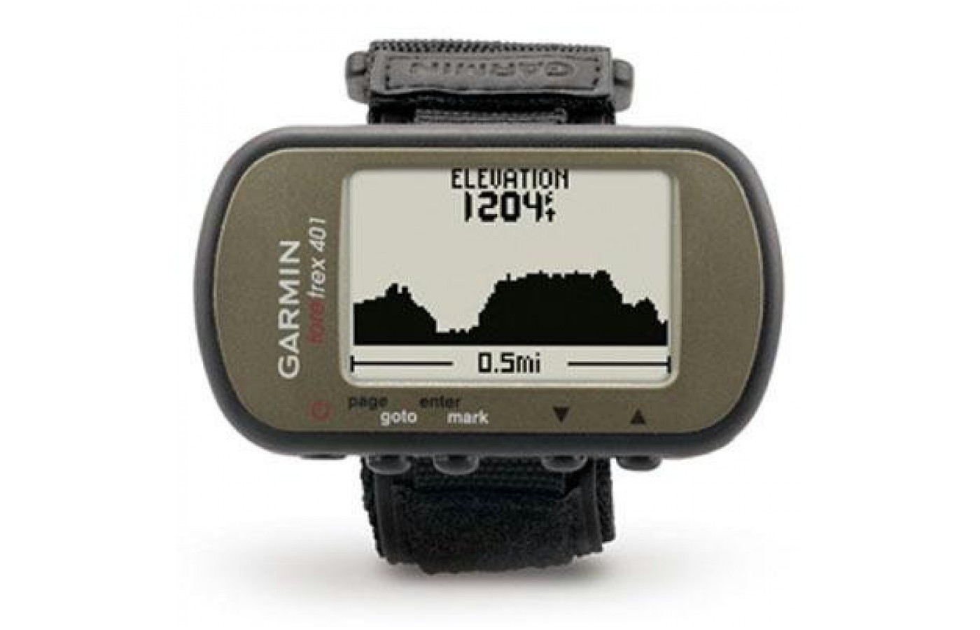
A graph of various altitude changes and the altitude is displayed on the Altimeter screen. Speed, altitude, coordinates, approximate time to the end of a route, time of travel, distance traveled, and maximum speed are the types of information contained on the General page.
Indicators on the General and Compass pages can be customized to suit the needs of the user. For example, the current time, altimeter information, or any other feature can replace the current speed indicator on the Compass page. Many customizable features can be accomplished in the settings.
Display
Rudimentary maps feature tracks, routes, and waypoints. The monochrome display screen permits flexibility and customization of data the user requires to be available. The monochrome monitor is another feature up for debate by users. Some prefer it, while for others being monochromatic is a deal breaker.
A satellite icon appears on the screen when the GPS is activated. The amount of battery life remaining is also displayed. With the push of a button, routes are tracked, locations are marked, and waypoints wirelessly shared with other Foretrex 401s. Regardless of where an adventure takes the user, there is no worry about getting lost. The path is tracked and displayed as a dotted trail.
Price
Serial GPS receivers that receive data from a computer, USB, and Bluetooth devices start between $50 and $100. Bigger color screens and more features range from $100 to $200. The MSRP of the Garmin Foretrex 401 is $199.99. It is available on Amazon for $169.99.
Key Features
* 9” X 1.7” X 0.9” dimensions
* 15-hour battery life
* 20 routes
* 64 X 100 screen pixels
* 500 waypoints
* Compass
* Hands-free navigation
* Pressure based altimeter
* Runs on two triple-A batteries
* Store and share routes
* TracBack retraces steps
* Weighs 2.26 ounces
* Window and Mac OS compatibility
* Wireless communication
Bottom Line
The inability to add detailed maps to the unit is among the most significant functions sacrificed. It is intended to be a basic GPS unit. There is no electronic mapping. It is marketed for tactical paramilitary use where the user carries a GPS only as a navigational aid rather than a navigation solution.
The Foretrex 401 meets the requirements of a great unit. The Foretrex 401 model has a barometric altimeter, an electronic compass a rugged waterproof body, and a GPS receiver that is highly sensitive. There are some issues getting data off the unit that may cause a few problems. A tester rated the Garmin Foretrex 401 as nine out of ten for accuracy, 9.5 for durability, seven for battery life, and 8.5 for ease of use.